17. Match the words with their antonyms:
| 1.wide | a. irrelevant |
| 2. attain | b. hidden |
| 3. appropriate | c. narrow |
| 4. displayed | d. crash |
| 5. form | e. coincide |
| 6. differ | f. loose |
Write short summary to text B.
Find as many words as possible in the crossword.
| C | S | E | R | I | E | S | J | M | V |
| O | C | Q | A | S | H | O | L | P | O |
| N | H | U | D | R | W | U | N | K | L |
| N | E | A | C | U | R | R | E | N | T |
| E | M | L | A | W | W | C | V | B | A |
| C | E | V | A | L | U | E | X | Z | G |
| T | C | I | R | C | U | I | T | U | E |
| R | E | S | I | S | T | A | N | C | E |
Unit 16
POSITION, LOCATION, ALTITUDE MEASUREMENT

1. Practice reading the following words:
Accurate, biases, altitude, barometric, geometric, transponder, pilot, appropriate, triangulation, via, interrogation, acquisition, omnidirectional, multiple.
What do you know about position and location measurement?
What previous experience has helped you to answer the previous question?
Read and translate text A.
Text A
Accurate monitoring of aircraft cruising height is required in order to reduce vertical separation to a minimum standard. Interest here focuses on the measurement of the distance between aircraft level and the sea surface level. This distance can be estimated onboard via barometric altimeters or it can be measured either onboard or in ground stations — via electronic radio wave systems. The indication of the first equipment is referred to as pressure altitude, or simply altitude, whereas that of the second category is referred to as geometric height or simply height (Fig.16.1). The altitude information at air traffic control (ATC) centers is based on pressure altitude measurement that the aircraft transponder system sends after it receives an appropriate interrogation. Actually, the altitude information is an atmospheric pressure measurement transformed to altitude indication through a formula expressing the pressure/altitude relationship. When a flight level is cleared for an aircraft, it actually means that the pilot must keep flying on an isobaric surface. However, the altimetry system may present systematic errors (biases) that are different for each airplane, and that significantly affect safety. Thus, the altimetry system performance as well as the aircraft height keeping performance must be monitored by an independent radar or satellite system.
Radar or satellite systems determine the position of an object through algorithms that are fed with range, or range difference, or range sum, or range and bearing measurements, and they estimate the object position vector employing appropriate techniques such as triangulation or trilateration. The primary radar measurements are contaminated by two kinds of errors: random and systematic errors.

Figure 16.1. Altitude measurement
The effect of random errors can be reduced by the use of appropriate noise rejection filters, such as a Kalman filter. The second kind of error is usually removed by calibrating the instrument if this is possible; otherwise, suitable algorithms must be invented to anticipate it.
The estimation may be derived in ground stations or onboard the aircraft according to where the data acquisition and processing is performed. In the latter case, the vertical position estimation has to be downlinked to the appropriate ATC center. Also, the estimation may be performed off-line or on-line.
Ground-based methods or systems are the Navigation Accuracy Measurement System (NAMS), the height estimation method with a single air traffic control radar, the method with one Secondary Surveillance Radar (SSR) and one omnidirectional radar, the Dual synchronized Autonomous Height Monitoring System (DAMS) and methods that use multiple SSRs and estimate the height by quadrilateration, or by the use of pseudorange measurements, or by the use of range difference measurements. On-board height measurement methods derive their estimates by trilateration using the Distance Measuring Equipment (DME) or the Global Positioning System (GPS) signals.
Match the columns.
| 1. accurate | a) taken to be the mean level between high and low tide |
| 2. surface level | b) a type of radio or radar transmitter-receiver that transmits signals automatically |
| 3. contaminate | c) inclination |
| 4. trilateration | d) a method of surveying in which a whole area is divided into triangles |
| 5. transponder | e) precise |
| 6. bias | f) to make impure |
6.Complete the sentences with the help of given words:
| rotation function range antenna |
1. It is composed of primary marine radar located under an airline and measures range R and depression angle β. The rotates about a vertical axis and scans the area above it with rate equal to one per 3 s. The principle exploited to derive the height estimate is that the varies as the aircraft passes through the data acquisition area. The rate of change of range is mainly a of the flight height z and secondarily of depression angle.
| horizontal axis method investigated traffic |
2. Navigation Institute the possibility to derive a height estimation with a very simple and inexpensive . The idea is to use a single radar normally used for air control. The radar antenna rotates around a once every 4 s and measures range R and bearing β.
Guess the Geometry of
a)  b)
b) 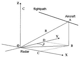
1. the Navigation Accuracy Measurement System (NAMS)
2. configuration of the height measurement system with a single air-traffic control radar.
8.Look at the pictures and discuss in pairs (groups):
- main principles of devices (antenna, radar)
- describe the geometry (a; b)
Translate into Ukrainian.
1. The pilot must keep flying on an isobaric surface.
2. Interest focuses on the measurement of the distance between aircraft level and the sea surface level.
3. The altitude information at air traffic control centers is based on pressure altitude measurement.
4. The altimetry system may present systematic errors (biases) that are different for each airplane.
5. The estimation may be derived in ground stations or onboard the aircraft according to where the data acquisition and processing is performed.
Retell text A.
10.Circle the correct form in parentheses.
1. Rita plays the violin (good/well).
2. That is an (intense/intensely) novel.
3. The sun is shining (bright/brightly).
4. The girls speak (fluent/fluently) French.
5. The boys speak Spanish (fluent/fluently).
6. The table has a (smooth/smoothy) surface.
7. We must figure our income tax returns (accurate/accurately).
8. We don't like to drink (bitter/bitterly) tea.
9. The plane will arrive (soon/soonly).
10. He had an accident because he was driving too (fast/fastly).
Дата: 2016-10-02, просмотров: 313.